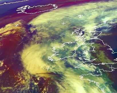
Gordon passes through
The reminents of Hurricane Gordon are in the process of passing over us. The system, now only a low pressure system, still possesses some tropical characteristics, rather unusual for a mid-latitude storm system. Not just this, but the scale of the system is smaller than many global models can resolve properly.

It does look like Limerick will escape the most of it wind wise but the rain could be very persistent and heavy. Localised flooding was seen already today on the Dock road, Moylish area, Ballysimon road, Hyde road and near the Coonagh roundabout.
Below is a Storm warning issued by Met Eireann
We shall wait and see. Could be nothing.No doubt the sandbags are at the ready around Clancy’s strand and the Sandmall and similar flood prone areas.

It does look like Limerick will escape the most of it wind wise but the rain could be very persistent and heavy. Localised flooding was seen already today on the Dock road, Moylish area, Ballysimon road, Hyde road and near the Coonagh roundabout.
Below is a Storm warning issued by Met Eireann
Issued at 21 September 2006 - 05:30
Severe Weather Alert
Becoming stormy for a time this evening and early tonight with winds gusting 100 to 120 Km/h in places. Some further flooding likely.Valid from 1800 21/9/06 to 0600 22/9/06
We shall wait and see. Could be nothing.No doubt the sandbags are at the ready around Clancy’s strand and the Sandmall and similar flood prone areas.


<< Return to Main Page