Weather warnings issued.
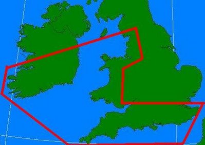
The crowd over at the Tornado and Storm Research Organisation (TORRO) have placed our area under a Tornado watch from 8pm Tuesday night until midday Wednesday 10th January.
Referring to the region enclosed in the big red line below, the site states,

Usually nothing becomes of these warnings but I just thought I'd throw it up anyway. There was after all ,a tornado in London there not too long ago.
Met.ie hasn’t mentioned a thing on this either.
Referring to the region enclosed in the big red line below, the site states,
Regions in and close to the WATCH area are at risk from isolated tornadoes, severe wind gusts to 65mph, occasional cloud-ground lightning, small hail, and heavy rain. The risk is two fold – the 1st, across S Eire – Wales – NW England, close to the point of occlusion, and the second across S Wales and S England along the occlusion/surface trough. The period of validity is rather long as the forecast cannot be monitored overnight, and the system is moving rather slowly.

Usually nothing becomes of these warnings but I just thought I'd throw it up anyway. There was after all ,a tornado in London there not too long ago.
Met.ie hasn’t mentioned a thing on this either.


<< Return to Main Page